
Thank you for supporting this site ❤️
Make a donation
Make a donation
Province of Concepción topographic map
Click on the map to display elevation.
Thank you for supporting this site ❤️
Make a donation
Make a donation
About this map
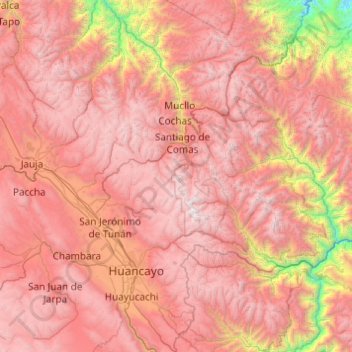
Name: Province of Concepción topographic map, elevation, terrain.
Location: Province of Concepción, Junín, 12125, Peru (-12.19441 -75.69430 -11.42674 -74.71784)
Average elevation: 3,633 m
Minimum elevation: 1,068 m
Maximum elevation: 5,510 m
Thank you for supporting this site ❤️
Make a donation
Make a donation
Other topographic maps
Click on a map to view its topography, its elevation and its terrain.
Thank you for supporting this site ❤️
Make a donation
Make a donation
Thank you for supporting this site ❤️
Make a donation
Make a donation