
Thank you for supporting this site ❤️
Make a donation
Make a donation
Nadi topographic map
Click on the map to display elevation.
Thank you for supporting this site ❤️
Make a donation
Make a donation
About this map
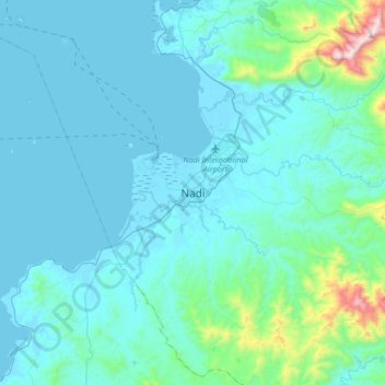
Name: Nadi topographic map, elevation, terrain.
Location: Nadi, Ba, Western, Fiji (-17.83927 177.37785 -17.75927 177.45785)
Average elevation: 12 m
Minimum elevation: -1 m
Maximum elevation: 100 m
Thank you for supporting this site ❤️
Make a donation
Make a donation
Other topographic maps
Click on a map to view its topography, its elevation and its terrain.