Thank you for supporting this site ❤️
Make a donation
Make a donation
Bembridge topographic map
Click on the map to display elevation.
Thank you for supporting this site ❤️
Make a donation
Make a donation
Bembridge
Close to the lifeboat station lies a coastguard lookout. Positioned at a high elevation, this offers views of the Solent meeting the English Channel to the east of the Isle of Wight. From this vantage point one is able to view a variety of watercraft year round, although there is more marine traffic in the summer.
Thank you for supporting this site ❤️
Make a donation
Make a donation
About this map
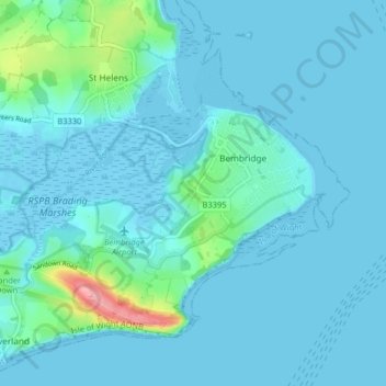
Name: Bembridge topographic map, elevation, terrain.
Location: Bembridge, Isle of Wight, England, United Kingdom (50.66481 -1.14335 50.70314 -1.06272)
Average elevation: 9 m
Minimum elevation: -8 m
Maximum elevation: 102 m
Thank you for supporting this site ❤️
Make a donation
Make a donation
Other topographic maps
Click on a map to view its topography, its elevation and its terrain.
Thank you for supporting this site ❤️
Make a donation
Make a donation
Thank you for supporting this site ❤️
Make a donation
Make a donation
Thank you for supporting this site ❤️
Make a donation
Make a donation
Thank you for supporting this site ❤️
Make a donation
Make a donation
Littleton Down
United Kingdom > England > Isle of Wight > Ventnor > Bonchurch
Average elevation: 111 m
Thank you for supporting this site ❤️
Make a donation
Make a donation
Thank you for supporting this site ❤️
Make a donation
Make a donation
Thank you for supporting this site ❤️
Make a donation
Make a donation
Thank you for supporting this site ❤️
Make a donation
Make a donation
Thank you for supporting this site ❤️
Make a donation
Make a donation
