
Thank you for supporting this site ❤️
Make a donation
Make a donation
Nittel topographic map
Click on the map to display elevation.
Thank you for supporting this site ❤️
Make a donation
Make a donation
About this map
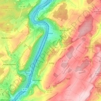
Name: Nittel topographic map, elevation, terrain.
Average elevation: 285 m
Minimum elevation: 128 m
Maximum elevation: 416 m
Thank you for supporting this site ❤️
Make a donation
Make a donation
Other topographic maps
Click on a map to view its topography, its elevation and its terrain.
Fastrau
Deutschland > Rheinland-Pfalz > Landkreis Trier-Saarburg
Fastrau liegt im Tal des Feller Bachs, eines Nebenflusses der Mosel, der bei Riol in die Mosel mündet. Die Fellerbachtalbrücke der A 1 führt über den Ortsteil Fastrau und zählt mit einer Höhe von 64 Metern zu den höchsten Brücken Deutschlands.
Average elevation: 218 m
Biebelhausen
Deutschland > Rheinland-Pfalz > Landkreis Trier-Saarburg > Biebelhausen
Average elevation: 210 m