
Thank you for supporting this site ❤️
Make a donation
Make a donation
Halbturn topographic map
Click on the map to display elevation.
Thank you for supporting this site ❤️
Make a donation
Make a donation
About this map
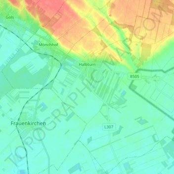
Name: Halbturn topographic map, elevation, terrain.
Average elevation: 131 m
Minimum elevation: 117 m
Maximum elevation: 166 m
Thank you for supporting this site ❤️
Make a donation
Make a donation
Other topographic maps
Click on a map to view its topography, its elevation and its terrain.
Bruckneudorf
Österreich > Burgenland > Bezirk Neusiedl am See > Bruckneusiedl
Average elevation: 170 m
Kirchberg
Österreich > Burgenland > Bezirk Neusiedl am See > Gemeinde Winden am See
Average elevation: 133 m