
Thank you for supporting this site ❤️
Make a donation
Make a donation
Soga topographic map
Click on the map to display elevation.
Thank you for supporting this site ❤️
Make a donation
Make a donation
About this map
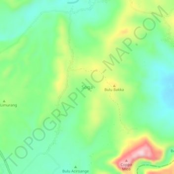
Name: Soga topographic map, elevation, terrain.
Location: Soga, Süd-Sulawesi, Sulawesi, Indonesien (-4.52661 119.95476 -4.48661 119.99476)
Average elevation: 137 m
Minimum elevation: 39 m
Maximum elevation: 327 m
Thank you for supporting this site ❤️
Make a donation
Make a donation
Other topographic maps
Click on a map to view its topography, its elevation and its terrain.
Thank you for supporting this site ❤️
Make a donation
Make a donation
Makassar
Indonesien > Süd-Sulawesi > Makassar
Makassar ist mit 199,26 km² die flächenmäßig größte Stadt Ostindonesiens. Die Stadt liegt im Zentrum Indonesiens an der südwestlichen Küste Sulawesis an der Straße von Makassar. Sie belegt einen flachen Küstenstreifen mit einer variierten Höhe zwischen 1 und 25 Meter über dem Meeresspiegel und…
Average elevation: 13 m