
Make a donation
Garsten topographic map
Click on the map to display elevation.
Make a donation
Garsten
Garsten liegt auf 298 m Höhe im Traunviertel am Rande der Eisenstadt Steyr. Die Ausdehnung der Marktgemeinde beträgt 11,4 km von Nord nach Süd und 10,7 km von West nach Ost. Ein Anteil von 39 % der Gemeindefläche ist bewaldet, 51,4 % sind landwirtschaftlich genutzt.
Make a donation
About this map
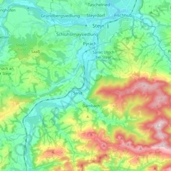
Name: Garsten topographic map, elevation, terrain.
Location: Garsten, Bezirk Steyr-Land, Oberösterreich, 4451, Österreich (47.95513 14.32900 48.05165 14.48076)
Average elevation: 446 m
Minimum elevation: 280 m
Maximum elevation: 830 m
Make a donation
Other topographic maps
Click on a map to view its topography, its elevation and its terrain.
Bodenwies
Österreich > Oberösterreich > Bezirk Steyr-Land > Weyer
Die Bodenwies ist mit 1540 m ü. A. Höhe der höchste Berg des Dürrensteigkamms, des östlichsten Teils der Oberösterreichischen Voralpen.
Average elevation: 1,123 m
Kleinraming
Österreich > Oberösterreich > Bezirk Steyr-Land > St. Ulrich bei Steyr
Average elevation: 513 m
Make a donation
Make a donation
Make a donation