
Patrick topographic map
Interactive map
Click on the map to display elevation.
About this map
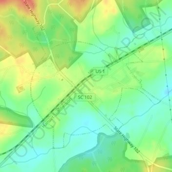
Name: Patrick topographic map, elevation, terrain.
Location: Patrick, Chesterfield County, South Carolina, United States (34.56542 -80.05454 34.58494 -80.02976)
Average elevation: 63 m
Minimum elevation: 43 m
Maximum elevation: 90 m
Other topographic maps
Click on a map to view its topography, its elevation and its terrain.
Cheraw State Park
United States > South Carolina > Chesterfield County
Cheraw State Park, Chesterfield County, South Carolina, United States
Average elevation: 49 m
Pageland
United States > South Carolina > Chesterfield County
Pageland, Chesterfield County, South Carolina, 29728, United States
Average elevation: 175 m
McBee
United States > South Carolina > Chesterfield County
McBee, Chesterfield County, South Carolina, United States
Average elevation: 137 m
Chesterfield
United States > South Carolina > Chesterfield County > Chesterfield
Chesterfield, Chesterfield County, South Carolina, 29709, United States
Average elevation: 79 m
McBee
United States > South Carolina > Chesterfield County > McBee
McBee, Chesterfield County, South Carolina, 29101, United States
Average elevation: 125 m
Cheathan Lake Dam D-3219
United States > South Carolina > Chesterfield County
Cheathan Lake Dam D-3219, Chesterfield County, South Carolina, 29520, United States
Average elevation: 43 m
Cheraw
United States > South Carolina > Chesterfield County
Cheraw, Chesterfield County, South Carolina, 29520, United States
Average elevation: 37 m