
Fondi topographic map
Interactive map
Click on the map to display elevation.
About this map
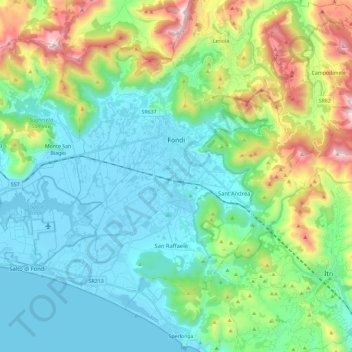
Name: Fondi topographic map, elevation, terrain.
Location: Fondi, Latina, Latium, 04022, Italien (41.27365 13.28113 41.40465 13.51276)
Average elevation: 261 m
Minimum elevation: -3 m
Maximum elevation: 1,044 m
Die Stadt Fondi liegt in einem Tal zu Füßen der Aurunker Berge und der Ausoni-Berge, die das Tal zu drei Seiten schließen. Offen ist das Tal zur vierten Seite in Richtung des Tyrrhenischen Meers. Die Stadtteile von Fondi sind Capratica, Cocuruzzo, Curtignano, Fasana, Gegni, Passignano, Querce di Fondi, Rene, Rio Claro, Salto di Fondi, San Magno, San Raffaele, Sant'Andrea, Sant'Oliva, Selva Vetere und Vardito. Das Gemeindegebiet erstreckt sich über eine Höhe von −2 bis 956 m s.l.m.
Other topographic maps
Click on a map to view its topography, its elevation and its terrain.