
Khyber Pakhtunkhwa topographic map
Interactive map
Click on the map to display elevation.
Khyber Pakhtunkhwa
Most precipitation falls as thunderstorms or snow during winter and spring, so that the climate at the lowest elevations is classed as Mediterranean (Csa), continental Mediterranean (Dsa) or semi-arid (BSk). Summers are extremely dry in the north of Chitral district and receive only a little rain in the south around Drosh.
About this map
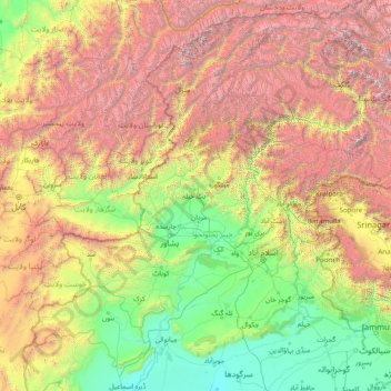
Name: Khyber Pakhtunkhwa topographic map, elevation, terrain.
Location: Khyber Pakhtunkhwa, Pakistan (31.94000 69.44000 37.06000 74.56000)
Average elevation: 2,135 m
Minimum elevation: 170 m
Maximum elevation: 7,856 m