
Make a donation
Modoc topographic map
Click on the map to display elevation.
Make a donation
About this map
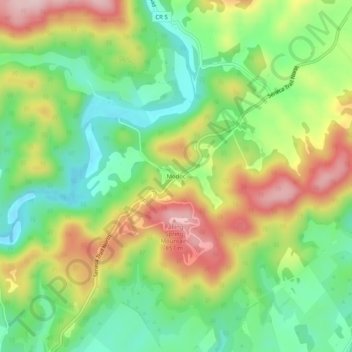
Name: Modoc topographic map, elevation, terrain.
Location: Modoc, Greenbrier County, West Virginia, United States (38.00429 -80.36508 38.04429 -80.32508)
Average elevation: 701 m
Minimum elevation: 592 m
Maximum elevation: 852 m
Make a donation
Other topographic maps
Click on a map to view its topography, its elevation and its terrain.
Fairlea
United States > West Virginia > Greenbrier County > Cedar Knoll Trailer Park
Average elevation: 639 m
Quinwood
United States > West Virginia > Greenbrier County > Quinwood
With the elevation and location on a western facing slope, Quinwood can easily see significant amounts of snowfall when winds from the northwest carry moisture from the great lakes and ride up the mountains. This event is called orographic lift. Snowfall amounts over one foot are very common during these…
Average elevation: 939 m