
Thank you for supporting this site ❤️
Make a donation
Make a donation
Großer Plöner See topographic map
Click on the map to display elevation.
Thank you for supporting this site ❤️
Make a donation
Make a donation
Großer Plöner See
Mit 28 km² Seefläche und einer Tiefe von bis zu 56 m ist der vollständig im Naturpark Holsteinische Schweiz liegende See der größte und tiefste in Schleswig-Holstein. Am Nordufer liegt die Kreisstadt Plön, mit dem Wahrzeichen des Sees, dem auf einer Anhöhe gelegenen Plöner Schloss. Weitere Orte am Ufer des Großen Plöner Sees sind Bosau, Dersau und Ascheberg.
Thank you for supporting this site ❤️
Make a donation
Make a donation
About this map
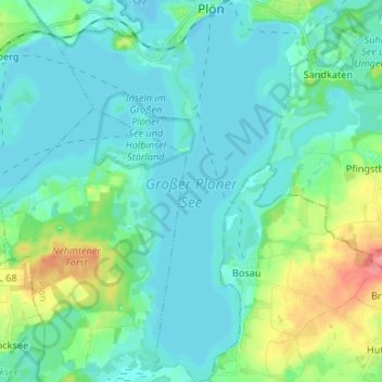
Name: Großer Plöner See topographic map, elevation, terrain.
Average elevation: 32 m
Minimum elevation: 17 m
Maximum elevation: 90 m
Thank you for supporting this site ❤️
Make a donation
Make a donation
Other topographic maps
Click on a map to view its topography, its elevation and its terrain.