
Thank you for supporting this site ❤️
Make a donation
Make a donation
Olhain topographic map
Click on the map to display elevation.
Thank you for supporting this site ❤️
Make a donation
Make a donation
About this map
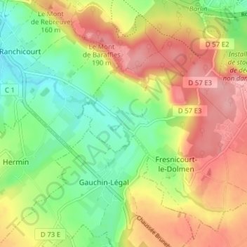
Name: Olhain topographic map, elevation, terrain.
Average elevation: 127 m
Minimum elevation: 69 m
Maximum elevation: 191 m
Thank you for supporting this site ❤️
Make a donation
Make a donation
Other topographic maps
Click on a map to view its topography, its elevation and its terrain.
Château d'Olhain
France > Hauts-de-France > Pas-de-Calais > Fresnicourt-le-Dolmen > Olhain
Average elevation: 116 m