
Make a donation
Bricquebec topographic map
Click on the map to display elevation.
Make a donation
About this map
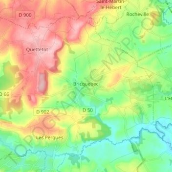
Name: Bricquebec topographic map, elevation, terrain.
Average elevation: 71 m
Minimum elevation: 6 m
Maximum elevation: 163 m
Make a donation
Other topographic maps
Click on a map to view its topography, its elevation and its terrain.
La Pasquerie
France > Normandie > Manche > Bricquebec-en-Cotentin > Quettetot
Average elevation: 112 m
Make a donation
Hameau Giot
France > Normandie > Manche > Bricquebec-en-Cotentin > Les Perques > Hameau Giot
Average elevation: 57 m
Catigny
France > Normandie > Manche > Bricquebec-en-Cotentin > Bricquebec > Catigny
Average elevation: 104 m
La Croix Blanche
France > Normandie > Manche > Bricquebec-en-Cotentin > Bricquebec
Average elevation: 89 m
Make a donation
Hameau es Cavelier
France > Normandie > Manche > Bricquebec-en-Cotentin > Quettetot
Average elevation: 113 m
Hameau Val Fontaine
France > Normandie > Manche > Bricquebec-en-Cotentin > Les Perques
Average elevation: 66 m