
Make a donation
Chi Chil Tah topographic map
Click on the map to display elevation.
Make a donation
About this map
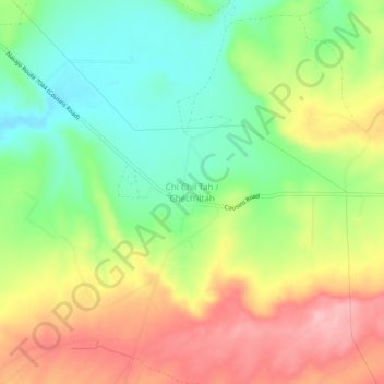
Name: Chi Chil Tah topographic map, elevation, terrain.
Average elevation: 2,101 m
Minimum elevation: 2,033 m
Maximum elevation: 2,182 m
Make a donation
Other topographic maps
Click on a map to view its topography, its elevation and its terrain.
Gallup
United States > New Mexico > McKinley County
Gallup, like most of the interior Mountain West, has a cool semiarid climate (Köppen BSk). The summers are hot during the day, but the high altitude and low humidity mean that nights remain distinctly cool; as late as July 2, 1997, the temperature fell to 31 °F (−1 °C). Despite the large diurnal…
Average elevation: 2,067 m
Ramah
United States > New Mexico > McKinley County > Ramah
Lying at 6926 feet above sea level, Ramah is considered by some as a high desert, but at higher elevations in includes tall pines, sandstone cliffs, and timber covered mountains. Much of the lower landscape in the surrounding area is covered with lava flows from the chain of volcanos to the south. Intermixed…
Average elevation: 2,184 m
Make a donation
Ramah
United States > New Mexico > McKinley County > Ramah
Lying at 6,926 feet (2,111 m) above sea level, Ramah is considered by some as a high desert, but at higher elevations it includes tall pines, sandstone cliffs, and timber-covered mountains. Much of the lower landscape in the surrounding area is covered with lava flows from the chain of volcanos to the south.
Average elevation: 2,184 m
Make a donation
Gallup
United States > New Mexico > McKinley County
Gallup, like most of the interior Mountain West, has a cool semiarid climate (Köppen BSk). The summers are hot during the day, but the high altitude and low humidity mean that nights remain distinctly cool; as late as July 2, 1997, the temperature fell to 31 °F (−1 °C). Despite the large diurnal…
Average elevation: 2,067 m
Make a donation
Crownpoint
United States > New Mexico > McKinley County
Crownpoint is in central McKinley County along New Mexico State Road 371, which leads south 23 miles (37 km) to Thoreau and Interstate 40, and north 83 miles (134 km) to Farmington. The community sits at an elevation of 6,851 feet (2,088 m) on land that drains toward the Chaco River 30 miles (48 km) to the…
Average elevation: 2,099 m