
Make a donation
Central topographic map
Click on the map to display elevation.
Make a donation
About this map
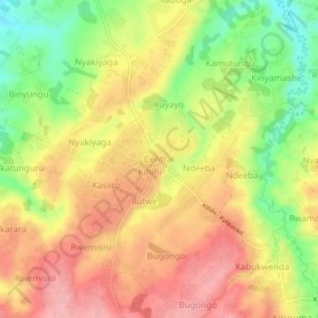
Name: Central topographic map, elevation, terrain.
Location: Central, Nyaka Sub-County, Kanungu, Western Region, Uganda (-0.76767 29.68105 -0.72767 29.72105)
Average elevation: 1,131 m
Minimum elevation: 1,057 m
Maximum elevation: 1,189 m
Make a donation
Other topographic maps
Click on a map to view its topography, its elevation and its terrain.
Bwindi Impenetrable National Park
Species diversity is a feature of the park. It provides habitat for 120 species of mammals, 350 species of birds, 310 species of butterflies, 27 species of frogs, chameleons, geckos, and many endangered species. Floristically, the park is among the most diverse forests in East Africa, with more than 1,000…
Average elevation: 1,643 m
Make a donation