
Thank you for supporting this site ❤️
Make a donation
Make a donation
McCall Creek topographic map
Click on the map to display elevation.
Thank you for supporting this site ❤️
Make a donation
Make a donation
About this map
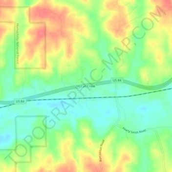
Name: McCall Creek topographic map, elevation, terrain.
Location: McCall Creek, Franklin County, Mississippi, United States (31.49267 -90.71871 31.53267 -90.67871)
Average elevation: 104 m
Minimum elevation: 75 m
Maximum elevation: 139 m
Thank you for supporting this site ❤️
Make a donation
Make a donation
Other topographic maps
Click on a map to view its topography, its elevation and its terrain.