
Thank you for supporting this site ❤️
Make a donation
Make a donation
Kiganjo topographic map
Click on the map to display elevation.
Thank you for supporting this site ❤️
Make a donation
Make a donation
About this map
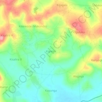
Name: Kiganjo topographic map, elevation, terrain.
Location: Kiganjo, Lwengo, Central Region, Uganda (-0.54794 31.43901 -0.50794 31.47901)
Average elevation: 1,251 m
Minimum elevation: 1,205 m
Maximum elevation: 1,321 m
Thank you for supporting this site ❤️
Make a donation
Make a donation