
Mediouna topographic map
Interactive map
Click on the map to display elevation.
About this map
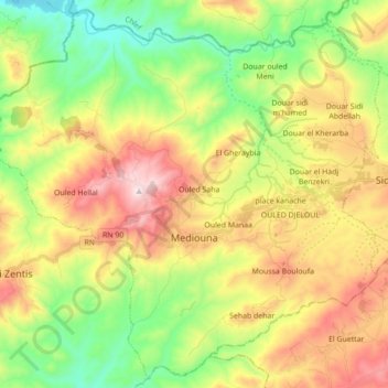
Name: Mediouna topographic map, elevation, terrain.
Location: Mediouna, Daïra Sidi M'hamed Ben Ali, Relizane, Algérie (36.07327 0.65812 36.20763 0.83258)
Average elevation: 371 m
Minimum elevation: 75 m
Maximum elevation: 770 m
Other topographic maps
Click on a map to view its topography, its elevation and its terrain.
Beni Zentis
Algérie > Relizane > Daïra Sidi M'hamed Ben Ali
Beni Zentis, Daïra Sidi M'hamed Ben Ali, Relizane, Algérie
Average elevation: 358 m