
Thank you for supporting this site ❤️
Make a donation
Make a donation
Granier topographic map
Click on the map to display elevation.
Thank you for supporting this site ❤️
Make a donation
Make a donation
Granier
Granier est une ancienne commune française située dans le département de la Savoie en région Auvergne-Rhône-Alpes à 1 250 mètres d'altitude. Le 1er janvier 2016, elle fusionne avec Montgirod et Aime pour former la commune nouvelle de Aime-la-Plagne.
Thank you for supporting this site ❤️
Make a donation
Make a donation
About this map
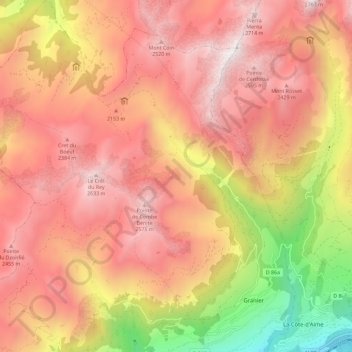
Name: Granier topographic map, elevation, terrain.
Average elevation: 1,925 m
Minimum elevation: 676 m
Maximum elevation: 2,708 m
Thank you for supporting this site ❤️
Make a donation
Make a donation
Other topographic maps
Click on a map to view its topography, its elevation and its terrain.
Thank you for supporting this site ❤️
Make a donation
Make a donation
Thank you for supporting this site ❤️
Make a donation
Make a donation
Refuge du Nant du Beurre
France > Auvergne-Rhône-Alpes > Savoie > Aime-la-Plagne > Le Villaret
Average elevation: 2,102 m
Thank you for supporting this site ❤️
Make a donation
Make a donation
Chalet de Prajourdan
France > Auvergne-Rhône-Alpes > Savoie > Aime-la-Plagne
Average elevation: 1,896 m
Thank you for supporting this site ❤️
Make a donation
Make a donation