
Make a donation
Glacier National Park topographic map
Click on the map to display elevation.
Make a donation
Glacier National Park
One of the most dramatic evidences of this overthrust is visible in the form of Chief Mountain, an isolated peak on the edge of the eastern boundary of the park rising 2,500 ft (800 m) above the Great Plains. There are six mountains in the park over 10,000 ft (3,000 m) in elevation, with Mount Cleveland at 10,466 ft (3,190 m) being the tallest. Appropriately named Triple Divide Peak sends waters towards the Pacific Ocean, Hudson Bay, and Gulf of Mexico watersheds. This peak can effectively be considered to be the apex of the North American continent, although the mountain is only 8,020 ft (2,444 m) above sea level.
Make a donation
About this map
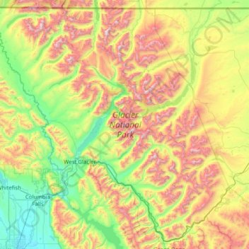
Name: Glacier National Park topographic map, elevation, terrain.
Location: Glacier National Park, Montana, United States (48.23370 -114.47550 49.00111 -113.24162)
Average elevation: 1,594 m
Minimum elevation: 888 m
Maximum elevation: 3,051 m
Make a donation
Other topographic maps
Click on a map to view its topography, its elevation and its terrain.
Gallatin Gateway
United States > Montana > Gallatin County
Gallatin Gateway is a census-designated place (CDP) in Gallatin County, Montana, United States. As of the 2020 census, Gallatin Gateway had a population of 967. Elevation is 4,953 ft (1,510 m).
Average elevation: 1,519 m
Make a donation
Make a donation
Make a donation
Make a donation
Make a donation
Make a donation
Fort Peck Indian Reservation Historical Marker
United States > Montana > Roosevelt County > Poplar
Average elevation: 600 m
Make a donation
Make a donation
Homestake Pass
United States > Montana > Silver Bow County > Butte > Highview
Average elevation: 1,947 m
Make a donation
Make a donation
Make a donation
Make a donation
Make a donation
Make a donation
Make a donation
Make a donation
Make a donation
Chapman Peak
United States > Montana > Glacier County
Chapman Peak (9,411 feet (2,868 m)) is located in the Livingston Range, Glacier National Park in the U.S. state of Montana. Chapman Peak is situated along the Continental Divide. The mountain is named for Robert H. Chapman, one of the US Geological Survey topographers who worked on mapping Glacier Park between…
Average elevation: 2,175 m
Make a donation
Make a donation
Make a donation
Make a donation
Make a donation
Crazy Mountains Historical Marker
United States > Montana > Wheatland County
Average elevation: 1,315 m
Make a donation
Make a donation
Make a donation