
Make a donation
Koserow topographic map
Click on the map to display elevation.
Make a donation
Koserow
The Streckelsberg (60 metres (200 ft)) is a steep coastal bluff and the highest elevation on the coast of Usedom. It offers wonderful views over the sea and, in clear weather, the hills of Mönchgut on the island of Rügen can be seen. To the northwest can be seen the island of Oie, recognisable at dusk by the lights of its lighthouse. To the southwest is the neighbouring island of Wolin.
Make a donation
About this map
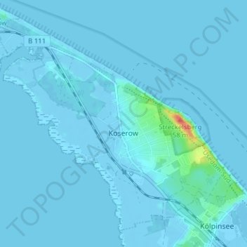
Name: Koserow topographic map, elevation, terrain.
Average elevation: 2 m
Minimum elevation: -6 m
Maximum elevation: 47 m
Make a donation
Other topographic maps
Click on a map to view its topography, its elevation and its terrain.
Riemserort
Germany > Mecklenburg-Vorpommern > Vorpommern-Greifswald > Greifswald
Average elevation: 1 m
Greifswald
Germany > Mecklenburg-Vorpommern > Vorpommern-Greifswald > Greifswald > Greifswald
Average elevation: 6 m
Make a donation
Löcknitz
Germany > Mecklenburg-Vorpommern > Vorpommern-Greifswald > Löcknitz > Löcknitz
Average elevation: 13 m
Bismark
Germany > Mecklenburg-Vorpommern > Vorpommern-Greifswald > Ramin > Bismark
Average elevation: 36 m