
Thank you for supporting this site ❤️
Make a donation
Make a donation
Ingelstad topographic map
Click on the map to display elevation.
Thank you for supporting this site ❤️
Make a donation
Make a donation
About this map
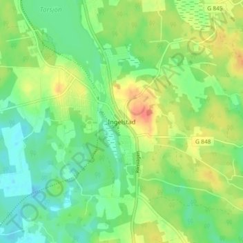
Name: Ingelstad topographic map, elevation, terrain.
Location: Ingelstad, Växjö kommun, Kronobergs län, 360 44, Zweden (56.72086 14.90900 56.76086 14.94900)
Average elevation: 161 m
Minimum elevation: 142 m
Maximum elevation: 188 m
Thank you for supporting this site ❤️
Make a donation
Make a donation
Other topographic maps
Click on a map to view its topography, its elevation and its terrain.