
Thank you for supporting this site ❤️
Make a donation
Make a donation
Hindu Kush topographic map
Click on the map to display elevation.
Thank you for supporting this site ❤️
Make a donation
Make a donation
About this map
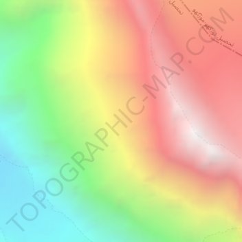
Name: Hindu Kush topographic map, elevation, terrain.
Average elevation: 5,281 m
Minimum elevation: 4,285 m
Maximum elevation: 6,252 m
Thank you for supporting this site ❤️
Make a donation
Make a donation
Other topographic maps
Click on a map to view its topography, its elevation and its terrain.
Bamburait River
Pakistan > Khyber Pakhtunkhwa > Chitrāl District > Chitral Tehsil
Average elevation: 2,999 m
Upper Gazikistan Glacier
Pakistan > Khyber Pakhtunkhwa > Chitrāl District > Chitral Tehsil
Average elevation: 5,086 m
Water Flow
Pakistan > Khyber Pakhtunkhwa > Chitrāl District > Chitral Tehsil > Parsan
Average elevation: 2,981 m
Thank you for supporting this site ❤️
Make a donation
Make a donation