
Thank you for supporting this site ❤️
Make a donation
Make a donation
Nord topographic map
Click on the map to display elevation.
Thank you for supporting this site ❤️
Make a donation
Make a donation
About this map
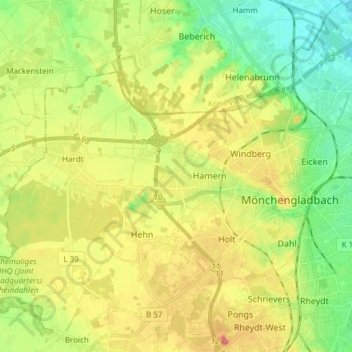
Name: Nord topographic map, elevation, terrain.
Location: Nord, Mönchengladbach, Nordrhein-Westfalen, Deutschland (51.17295 6.31288 51.22913 6.46373)
Average elevation: 68 m
Minimum elevation: 33 m
Maximum elevation: 113 m
Thank you for supporting this site ❤️
Make a donation
Make a donation
Other topographic maps
Click on a map to view its topography, its elevation and its terrain.
Mönchengladbach
Deutschland > Nordrhein-Westfalen > Mönchengladbach
Der höchste Punkt ist die mit 133 m ü. NN nach dem Zweiten Weltkrieg aus Trümmern aufgeschüttete Rheydter Höhe. Der niedrigste Punkt sind die Nierswiesen im Stadtteil Donk mit 35 m ü. NN. Die Länge der Stadtgrenze beträgt insgesamt 86 Kilometer. Die größte Nord-Süd-Ausdehnung beträgt 17; die…
Average elevation: 59 m
Thank you for supporting this site ❤️
Make a donation
Make a donation
Thank you for supporting this site ❤️
Make a donation
Make a donation
Thank you for supporting this site ❤️
Make a donation
Make a donation