
Le Val topographic map
Interactive map
Click on the map to display elevation.
About this map
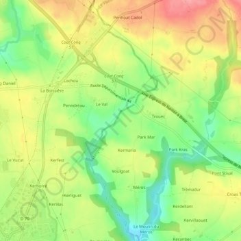
Name: Le Val topographic map, elevation, terrain.
Average elevation: 77 m
Minimum elevation: 28 m
Maximum elevation: 127 m
Other topographic maps
Click on a map to view its topography, its elevation and its terrain.
Concarneau
France > Bretagne > Finistère > Concarneau
Concarneau, Quimper, Finistère, Bretagne, France métropolitaine, 29900, France
Average elevation: 46 m