
Thank you for supporting this site ❤️
Make a donation
Make a donation
Botiza topographic map
Click on the map to display elevation.
Thank you for supporting this site ❤️
Make a donation
Make a donation
About this map
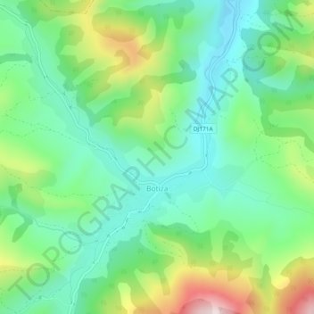
Name: Botiza topographic map, elevation, terrain.
Location: Botiza, Maramureș, 437065, Roumanie (47.65596 24.12739 47.68734 24.16028)
Average elevation: 573 m
Minimum elevation: 443 m
Maximum elevation: 857 m
Thank you for supporting this site ❤️
Make a donation
Make a donation
Other topographic maps
Click on a map to view its topography, its elevation and its terrain.
Seini
Seini est une ville de la vallée du Someș, située à la limite du județ de Maramureș avec le județ de Satu Mare, à 26 km à l'ouest de Baia Mare et à 42 km de Satu Mare. L'altitude maximale de la commune est de 960 m dans sa partie nord, dans les monts Igniș (Munții ignișului).
Average elevation: 199 m
Thank you for supporting this site ❤️
Make a donation
Make a donation