
Thank you for supporting this site ❤️
Make a donation
Make a donation
Lustnau topographic map
Click on the map to display elevation.
Thank you for supporting this site ❤️
Make a donation
Make a donation
About this map
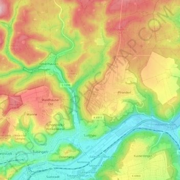
Name: Lustnau topographic map, elevation, terrain.
Average elevation: 415 m
Minimum elevation: 305 m
Maximum elevation: 537 m
Thank you for supporting this site ❤️
Make a donation
Make a donation
Other topographic maps
Click on a map to view its topography, its elevation and its terrain.
Pfrondorf
Deutschland > Baden-Württemberg > Landkreis Tübingen > Tübingen > Pfrondorf
Average elevation: 410 m
Lichtenberger Höhe
Deutschland > Baden-Württemberg > Landkreis Tübingen > Tübingen
Average elevation: 353 m
Sengental
Deutschland > Baden-Württemberg > Landkreis Tübingen > Tübingen > Bühl
Average elevation: 412 m
Thank you for supporting this site ❤️
Make a donation
Make a donation
Sengental
Deutschland > Baden-Württemberg > Landkreis Tübingen > Tübingen > Bühl
Average elevation: 412 m