
Thank you for supporting this site ❤️
Make a donation
Make a donation
Verdun topographic map
Click on the map to display elevation.
Thank you for supporting this site ❤️
Make a donation
Make a donation
About this map
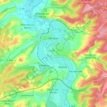
Name: Verdun topographic map, elevation, terrain.
Location: Verdun, Meuse, Grand Est, Metropolitan France, 55100, France (49.11262 5.28097 49.17533 5.44085)
Average elevation: 256 m
Minimum elevation: 187 m
Maximum elevation: 387 m
Thank you for supporting this site ❤️
Make a donation
Make a donation
Other topographic maps
Click on a map to view its topography, its elevation and its terrain.