
Thank you for supporting this site ❤️
Make a donation
Make a donation
Central Equatoria topographic map
Click on the map to display elevation.
Thank you for supporting this site ❤️
Make a donation
Make a donation
About this map
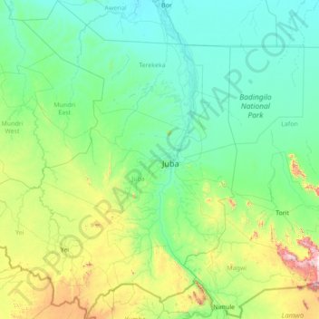
Name: Central Equatoria topographic map, elevation, terrain.
Location: Central Equatoria, South Sudan (3.48898 29.79678 6.25106 32.17315)
Average elevation: 647 m
Minimum elevation: 422 m
Maximum elevation: 2,417 m
Thank you for supporting this site ❤️
Make a donation
Make a donation
Other topographic maps
Click on a map to view its topography, its elevation and its terrain.