
Thank you for supporting this site ❤️
Make a donation
Make a donation
Kleingölitz topographic map
Click on the map to display elevation.
Thank you for supporting this site ❤️
Make a donation
Make a donation
Kleingölitz
Kleingölitz liegt am Fuß der Kesselwände in einer Mulde, die südlich von kleinen Anhöhen zur Bundesstraße 88 von Bad Blankenburg nach Königsee abgegrenzt wird. Von der B88 ist das Dorf nördlich etwas abseits liegend gut und schnell erreichbar. Die Muschelkalksteinwände bewirken ein besonders mildes Kleinklima durch die Südhanglage. Sie sind aber auch grundwasserferne Standorte, was durch höhere Niederschläge in diesem Vorgebirggebiet ausgeglichen wird.
Thank you for supporting this site ❤️
Make a donation
Make a donation
About this map
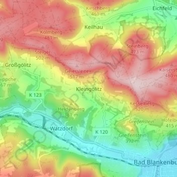
Name: Kleingölitz topographic map, elevation, terrain.
Average elevation: 366 m
Minimum elevation: 219 m
Maximum elevation: 525 m
Thank you for supporting this site ❤️
Make a donation
Make a donation