
Thank you for supporting this site ❤️
Make a donation
Make a donation
Northwest Hills topographic map
Click on the map to display elevation.
Thank you for supporting this site ❤️
Make a donation
Make a donation
About this map
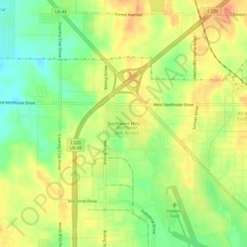
Name: Northwest Hills topographic map, elevation, terrain.
Average elevation: 103 m
Minimum elevation: 80 m
Maximum elevation: 121 m
Thank you for supporting this site ❤️
Make a donation
Make a donation
Other topographic maps
Click on a map to view its topography, its elevation and its terrain.
Lake Catherine
United States > Mississippi > Hinds County > Jackson > Lost Lake
Average elevation: 100 m