
Lataguri topographic map
Interactive map
Click on the map to display elevation.
About this map
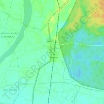
Name: Lataguri topographic map, elevation, terrain.
Location: Lataguri, Mal, Jalpaiguri District, West Bengal, 735219, India (26.68654 88.74898 26.72654 88.78898)
Average elevation: 99 m
Minimum elevation: 89 m
Maximum elevation: 117 m
Other topographic maps
Click on a map to view its topography, its elevation and its terrain.
Odlabari
India > West Bengal > Mal
Odlabari, Mal, Jalpaiguri District, West Bengal, 735222, India
Average elevation: 168 m
Kranti
India > West Bengal > Mal
Kranti, Mal, Jalpaiguri District, West Bengal, 735218, India
Average elevation: 100 m
Bagrakote
India > West Bengal > Mal
Bagrakote, Mal, Jalpaiguri District, West Bengal, India
Average elevation: 212 m
Demka Jhora
India > West Bengal > Mal > Demka Jhora
Demka Jhora, Mal, Jalpaiguri, West Bengal, India
Average elevation: 119 m