
Thank you for supporting this site ❤️
Make a donation
Make a donation
East Dubuque topographic map
Click on the map to display elevation.
Thank you for supporting this site ❤️
Make a donation
Make a donation
East Dubuque
Like the rest of Jo Daviess County, the city is topographically a part of the Driftless Area.
Thank you for supporting this site ❤️
Make a donation
Make a donation
About this map
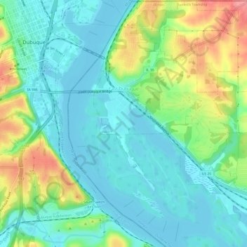
Name: East Dubuque topographic map, elevation, terrain.
Average elevation: 207 m
Minimum elevation: 181 m
Maximum elevation: 270 m
Thank you for supporting this site ❤️
Make a donation
Make a donation
Other topographic maps
Click on a map to view its topography, its elevation and its terrain.