
Chesterfield topographic map
Interactive map
Click on the map to display elevation.
About this map
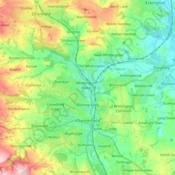
Name: Chesterfield topographic map, elevation, terrain.
Location: Chesterfield, Derbyshire, Inglaterra, Reino Unido (53.21242 -1.48429 53.29903 -1.30130)
Average elevation: 127 m
Minimum elevation: 41 m
Maximum elevation: 305 m
Other topographic maps
Click on a map to view its topography, its elevation and its terrain.
Edensor CP
Reino Unido > Inglaterra > Derbyshire > Derbyshire Dales
Edensor CP, Derbyshire Dales, Derbyshire, Inglaterra, Reino Unido
Average elevation: 182 m
Marlpool
Reino Unido > Inglaterra > Derbyshire > Amber Valley
Marlpool, Amber Valley, Derbyshire, Inglaterra, DE75 7BU, Reino Unido
Average elevation: 90 m
Derbyshire Dales
Reino Unido > Inglaterra > Derbyshire
Derbyshire Dales, Derbyshire, Inglaterra, Reino Unido
Average elevation: 198 m
Derby
Reino Unido > Inglaterra > Derbyshire > Derby
Derby, Derbyshire, East Midlands, Inglaterra, DE1 2AA, Reino Unido
Average elevation: 96 m
South Yorkshire
Reino Unido > Inglaterra > Derbyshire
South Yorkshire, Derbyshire, South Yorkshire, Inglaterra, Reino Unido
Average elevation: 123 m