
Wels-Land topographic map
Interactive map
Click on the map to display elevation.
About this map
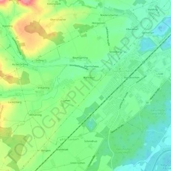
Name: Wels-Land topographic map, elevation, terrain.
Average elevation: 355 m
Minimum elevation: 321 m
Maximum elevation: 419 m
Other topographic maps
Click on a map to view its topography, its elevation and its terrain.
Sirfling
Österreich > Oberösterreich > Gunskirchen > Sirfling
Sirfling, Gunskirchen, Wels-Land, Oberösterreich, 4623, Österreich
Average elevation: 370 m