
Thank you for supporting this site ❤️
Make a donation
Make a donation
Ezelsdorf topographic map
Click on the map to display elevation.
Thank you for supporting this site ❤️
Make a donation
Make a donation
About this map
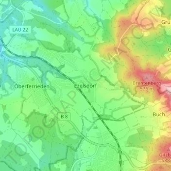
Name: Ezelsdorf topographic map, elevation, terrain.
Average elevation: 464 m
Minimum elevation: 401 m
Maximum elevation: 588 m
Thank you for supporting this site ❤️
Make a donation
Make a donation
Other topographic maps
Click on a map to view its topography, its elevation and its terrain.
90559
Deutschland > Bayern > Landkreis Nürnberger Land > Burgthann > Ezelsdorf > Osterhof
Average elevation: 447 m