
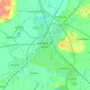
Newark on Trent topographic map
Interactive map
Click on the map to display elevation.
About this map
Name: Newark on Trent topographic map, elevation, terrain.
Average elevation: 18 m
Minimum elevation: 1 m
Maximum elevation: 72 m
Other topographic maps
Click on a map to view its topography, its elevation and its terrain.
Averham CP
United Kingdom > England > Nottinghamshire > Newark and Sherwood
Averham CP, Newark and Sherwood, Nottinghamshire, England, United Kingdom
Average elevation: 23 m
Caunton CP
United Kingdom > England > Nottinghamshire > Newark and Sherwood
Caunton CP, Newark and Sherwood, Nottinghamshire, England, United Kingdom
Average elevation: 42 m
Thorpe
United Kingdom > England > Nottinghamshire > Newark and Sherwood
Thorpe, Newark and Sherwood, Nottinghamshire, England, United Kingdom
Average elevation: 16 m
Bleasby
United Kingdom > England > Nottinghamshire > Newark and Sherwood
Bleasby, Newark and Sherwood, Nottinghamshire, England, NG14 7HF, United Kingdom
Average elevation: 28 m
Wigsley
United Kingdom > England > Nottinghamshire > Newark and Sherwood
Wigsley, Newark and Sherwood, Nottinghamshire, England, United Kingdom
Average elevation: 7 m
Kelham CP
United Kingdom > England > Nottinghamshire > Newark and Sherwood
Kelham CP, Newark and Sherwood, Nottinghamshire, England, United Kingdom
Average elevation: 23 m
East Stoke CP
United Kingdom > England > Nottinghamshire > Newark and Sherwood
East Stoke CP, Newark and Sherwood, Nottinghamshire, England, United Kingdom
Average elevation: 24 m
Sherwood Forest NNR
United Kingdom > England > Nottinghamshire > Newark and Sherwood > Ollerton > Edwinstowe CP
Sherwood Forest NNR, Broad Drive, Edwinstowe CP, Ollerton, Newark and Sherwood, Nottinghamshire, England, NG21 9HN, United Kingdom
Average elevation: 71 m
Blidworth Bottoms
United Kingdom > England > Nottinghamshire > Newark and Sherwood > Blidworth CP
Blidworth Bottoms, Blidworth CP, Newark and Sherwood, Nottinghamshire, England, NG21 0NR, United Kingdom
Average elevation: 107 m
Laxton
United Kingdom > England > Nottinghamshire > Newark and Sherwood
Laxton, Newark and Sherwood, Nottinghamshire, England, NG22 0NX, United Kingdom
Average elevation: 62 m
Halam CP
United Kingdom > England > Nottinghamshire > Newark and Sherwood
Halam CP, Newark and Sherwood, Nottinghamshire, England, United Kingdom
Average elevation: 57 m
Eakring CP
United Kingdom > England > Nottinghamshire > Newark and Sherwood
Eakring CP, Newark and Sherwood, Nottinghamshire, England, United Kingdom
Average elevation: 75 m
Coddington
United Kingdom > England > Nottinghamshire > Newark and Sherwood
Coddington, Newark and Sherwood, Nottinghamshire, England, NG24 2PR, United Kingdom
Average elevation: 23 m
Elston
United Kingdom > England > Nottinghamshire > Newark and Sherwood
Elston, Newark and Sherwood, Nottinghamshire, England, United Kingdom
Average elevation: 24 m
Sutton-on-Trent CP
United Kingdom > England > Nottinghamshire > Newark and Sherwood
Sutton-on-Trent CP, Newark and Sherwood, Nottinghamshire, England, United Kingdom
Average elevation: 16 m
Staythorpe CP
United Kingdom > England > Nottinghamshire > Newark and Sherwood
Staythorpe CP, Newark and Sherwood, Nottinghamshire, England, United Kingdom
Average elevation: 16 m
Bulcote
United Kingdom > England > Nottinghamshire > Newark and Sherwood
Bulcote, Newark and Sherwood, Nottinghamshire, England, United Kingdom
Average elevation: 33 m
Carlton-on-Trent CP
United Kingdom > England > Nottinghamshire > Newark and Sherwood
Carlton-on-Trent CP, Newark and Sherwood, Nottinghamshire, England, United Kingdom
Average elevation: 12 m
Farndon
United Kingdom > England > Nottinghamshire > Newark and Sherwood > Farndon
Farndon, Newark and Sherwood, Nottinghamshire, England, NG24 3SS, United Kingdom
Average elevation: 14 m
Southwell CP
United Kingdom > England > Nottinghamshire > Newark and Sherwood
Southwell CP, Newark and Sherwood, Nottinghamshire, England, United Kingdom
Average elevation: 47 m
Lowdham CP
United Kingdom > England > Nottinghamshire > Newark and Sherwood
Lowdham CP, Newark and Sherwood, Nottinghamshire, England, United Kingdom
Average elevation: 38 m
Bilsthorpe CP
United Kingdom > England > Nottinghamshire > Newark and Sherwood
Bilsthorpe CP, Newark and Sherwood, Nottinghamshire, England, United Kingdom
Average elevation: 75 m
Kneesall CP
United Kingdom > England > Nottinghamshire > Newark and Sherwood
Kneesall CP, Newark and Sherwood, Nottinghamshire, England, United Kingdom
Average elevation: 71 m
Epperstone CP
United Kingdom > England > Nottinghamshire > Newark and Sherwood
Epperstone CP, Newark and Sherwood, Nottinghamshire, England, United Kingdom
Average elevation: 69 m
Danethorpe Hill
United Kingdom > England > Nottinghamshire > Newark and Sherwood
Danethorpe Hill, Newark and Sherwood, Nottinghamshire, East Midlands, England, NG24 2PB, United Kingdom
Average elevation: 22 m
Newark
United Kingdom > England > Nottinghamshire > Newark and Sherwood
Newark, Newark and Sherwood, Nottinghamshire, England, United Kingdom
Average elevation: 17 m
Egmanton CP
United Kingdom > England > Nottinghamshire > Newark and Sherwood
Egmanton CP, Newark and Sherwood, Nottinghamshire, England, United Kingdom
Average elevation: 50 m
Caythorpe
United Kingdom > England > Nottinghamshire > Newark and Sherwood
Caythorpe, Newark and Sherwood, Nottinghamshire, East Midlands, England, United Kingdom
Average elevation: 22 m
Blidworth CP
United Kingdom > England > Nottinghamshire > Newark and Sherwood
Blidworth CP, Newark and Sherwood, Nottinghamshire, England, United Kingdom
Average elevation: 107 m
Kings Clipstone
United Kingdom > England > Nottinghamshire > Newark and Sherwood
Kings Clipstone, Newark and Sherwood, Nottinghamshire, England, NG21 9BW, United Kingdom
Average elevation: 81 m
Fernwood CP
United Kingdom > England > Nottinghamshire > Newark and Sherwood > Fernwood CP
Fernwood CP, Newark and Sherwood, Nottinghamshire, England, United Kingdom
Average elevation: 18 m
Rainworth CP
United Kingdom > England > Nottinghamshire > Newark and Sherwood
Rainworth CP, Newark and Sherwood, Nottinghamshire, England, United Kingdom
Average elevation: 111 m
Balderton
United Kingdom > England > Nottinghamshire > Newark and Sherwood
Balderton, Newark and Sherwood, Nottinghamshire, England, NG24 3PU, United Kingdom
Average elevation: 19 m
Syerston
United Kingdom > England > Nottinghamshire > Newark and Sherwood
Syerston, Newark and Sherwood, Nottinghamshire, England, NG23 5ND, United Kingdom
Average elevation: 34 m
Halloughton
United Kingdom > England > Nottinghamshire > Newark and Sherwood
Halloughton, Newark and Sherwood, Nottinghamshire, England, NG25 0QP, United Kingdom
Average elevation: 61 m
North Muskham CP
United Kingdom > England > Nottinghamshire > Newark and Sherwood
North Muskham CP, Newark and Sherwood, Nottinghamshire, England, United Kingdom
Average elevation: 11 m
Rufford CP
United Kingdom > England > Nottinghamshire > Newark and Sherwood
Rufford CP, Ollerton, Newark and Sherwood, Nottinghamshire, England, United Kingdom
Average elevation: 76 m
Harby
United Kingdom > England > Nottinghamshire > Newark and Sherwood
Harby, Newark and Sherwood, Nottinghamshire, England, United Kingdom
Average elevation: 8 m
Edwinstowe CP
United Kingdom > England > Nottinghamshire > Newark and Sherwood
Edwinstowe CP, Newark and Sherwood, Nottinghamshire, England, United Kingdom
Average elevation: 68 m
Collingham CP
United Kingdom > England > Nottinghamshire > Newark and Sherwood
Collingham CP, Newark and Sherwood, Nottinghamshire, England, United Kingdom
Average elevation: 15 m