
Thank you for supporting this site ❤️
Make a donation
Make a donation
Costilla topographic map
Click on the map to display elevation.
Thank you for supporting this site ❤️
Make a donation
Make a donation
About this map
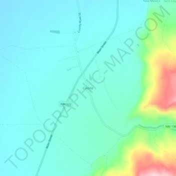
Name: Costilla topographic map, elevation, terrain.
Location: Costilla, Taos County, New Mexico, 87624, United States (36.95541 -105.55082 36.99541 -105.51082)
Average elevation: 2,398 m
Minimum elevation: 2,354 m
Maximum elevation: 2,574 m
Thank you for supporting this site ❤️
Make a donation
Make a donation
Other topographic maps
Click on a map to view its topography, its elevation and its terrain.
Taos Ski Valley
United States > New Mexico > Taos County
Taos Ski Valley is a village and alpine ski resort in the southwestern United States, located in Taos County, New Mexico. The population was 69 at the 2010 census. Until March 19, 2008, it was one of four ski resorts in America to prohibit snowboarding. The Kachina lift, constructed in 2014, serves one of the…
Average elevation: 3,307 m