
Thank you for supporting this site ❤️
Make a donation
Make a donation
Dundee Township topographic map
Click on the map to display elevation.
Thank you for supporting this site ❤️
Make a donation
Make a donation
About this map
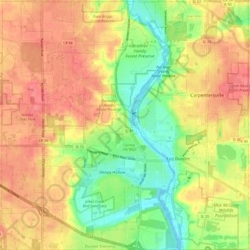
Name: Dundee Township topographic map, elevation, terrain.
Location: Dundee Township, Kane County, Illinois, United States (42.06687 -88.35507 42.15425 -88.23819)
Average elevation: 258 m
Minimum elevation: 217 m
Maximum elevation: 293 m
Thank you for supporting this site ❤️
Make a donation
Make a donation
Other topographic maps
Click on a map to view its topography, its elevation and its terrain.