
Bad Zwischenahn topographic map
Interactive map
Click on the map to display elevation.
About this map
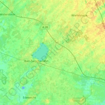
Name: Bad Zwischenahn topographic map, elevation, terrain.
Average elevation: 10 m
Minimum elevation: -13 m
Maximum elevation: 24 m
Other topographic maps
Click on a map to view its topography, its elevation and its terrain.
Metjendorf
Allemagne > Basse-Saxe > Ammerland (arrondissement) > Wiefelstede
Metjendorf, Wiefelstede, Ammerland (arrondissement), Basse-Saxe, 26215, Allemagne
Average elevation: 13 m
Bad Zwischenahn
Allemagne > Basse-Saxe > Ammerland (arrondissement)
Bad Zwischenahn, Ammerland (arrondissement), Basse-Saxe, 26160, Allemagne
Average elevation: 9 m