
Thank you for supporting this site ❤️
Make a donation
Make a donation
Rasch topographic map
Click on the map to display elevation.
Thank you for supporting this site ❤️
Make a donation
Make a donation
About this map
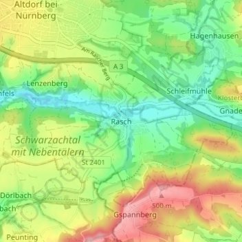
Name: Rasch topographic map, elevation, terrain.
Average elevation: 425 m
Minimum elevation: 365 m
Maximum elevation: 509 m
Thank you for supporting this site ❤️
Make a donation
Make a donation
Other topographic maps
Click on a map to view its topography, its elevation and its terrain.
90518
Deutschland > Bayern > Landkreis Nürnberger Land > Altdorf bei Nürnberg > Oberwellitzleithen
Average elevation: 433 m