
Make a donation
Felbridge topographic map
Click on the map to display elevation.
Make a donation
Felbridge
Elevations range between 115m AOB towards the south of the eastern boundary, fields adjoining Chartham Wood and similarly 102m AOB along West Park Road by the Effingham Park Hotel in the southwest, to 53m AOB along Felbridge Water between Felcourt and Newchapel, in the northeast of the parish, a tributary of the River Eden.
Make a donation
About this map
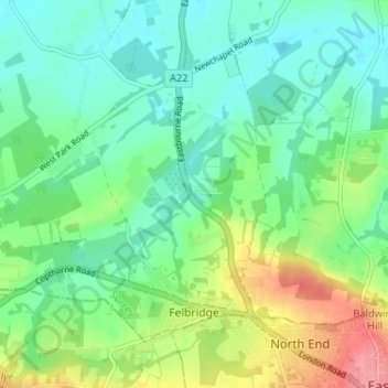
Name: Felbridge topographic map, elevation, terrain.
Location: Felbridge, Tandridge, Surrey, England, United Kingdom (51.13677 -0.09753 51.16760 -0.03315)
Average elevation: 76 m
Minimum elevation: 51 m
Maximum elevation: 130 m
Make a donation
Other topographic maps
Click on a map to view its topography, its elevation and its terrain.
Redhill
United Kingdom > England > Surrey > Reigate and Banstead
To the north, the town joins with the village of Merstham, north of which there is a "wind gap" in the chalk hills of the North Downs, at an elevation of 120 metres (390 feet) above sea level, through which the A23 road heads in from London. Geologists have speculated that there may once have been a…
Average elevation: 107 m
Make a donation
Camberley
United Kingdom > England > Surrey > Surrey Heath
The Staff College, to the north of Camberley town centre, is part of the Joint Services Command and Staff College, which provides training and education for established officers in the British Armed Forces and civil servants in the Ministry of Defence. The institution has its origins in the Royal Military…
Average elevation: 88 m
Box Hill
United Kingdom > England > Surrey > Mole Valley > Pixham
The 15.8 km (9.8 mi) Box Hill Olympic circuit is generally cycled in an anticlockwise direction and begins to the south of the village of Mickleham with an ascent of the hill via the Zig Zag Road. From the National Trust Visitor Centre, the route turns eastwards, running along the escarpment and through the…
Average elevation: 105 m
Make a donation