
Thank you for supporting this site ❤️
Make a donation
Make a donation
Bazaoun topographic map
Click on the map to display elevation.
Thank you for supporting this site ❤️
Make a donation
Make a donation
About this map
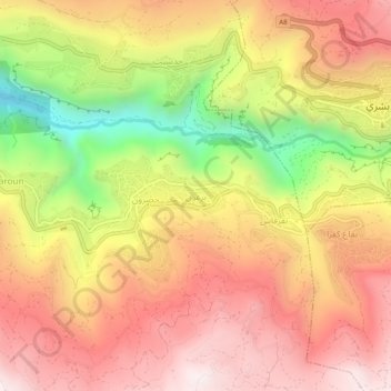
Name: Bazaoun topographic map, elevation, terrain.
Average elevation: 1,468 m
Minimum elevation: 889 m
Maximum elevation: 1,866 m
Thank you for supporting this site ❤️
Make a donation
Make a donation
Other topographic maps
Click on a map to view its topography, its elevation and its terrain.
Batroûn
Liban > Gouvernorat du Liban Nord
Cependant avec le développement commercial du centre-ville historique, l'urbanisation des premières hauteurs surplombant la ville fit ainsi connaître à Batroun une nouvelle ère de développement urbain, créant dès lors une 'fonctionnalisation' de son tissu urbain, avec un centre-ville de plus en plus…
Average elevation: 31 m
Thank you for supporting this site ❤️
Make a donation
Make a donation