
Village of Menands topographic map
Interactive map
Click on the map to display elevation.
About this map
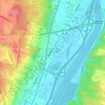
Name: Village of Menands topographic map, elevation, terrain.
Average elevation: 34 m
Minimum elevation: -1 m
Maximum elevation: 104 m
Other topographic maps
Click on a map to view its topography, its elevation and its terrain.
Boght Corners
United States > New York > Albany County > Town of Colonie
Boght Corners, Town of Colonie, Albany County, New York, 12047, United States
Average elevation: 84 m
Latham
United States > New York > Albany County > Town of Colonie > Latham
Latham, Town of Colonie, Albany County, New York, 12110, United States
Average elevation: 96 m
Stanford Heights
United States > New York > Albany County > Town of Colonie > Stanford Heights
Stanford Heights, Town of Colonie, Albany County, New York, 12304, United States
Average elevation: 106 m
Alleghany Park
United States > New York > Albany County > Town of Colonie
Alleghany Park, Town of Colonie, Albany County, New York, United States
Average elevation: 37 m