
Thank you for supporting this site ❤️
Make a donation
Make a donation
Longs topographic map
Click on the map to display elevation.
Thank you for supporting this site ❤️
Make a donation
Make a donation
About this map
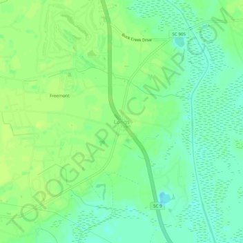
Name: Longs topographic map, elevation, terrain.
Location: Longs, Horry County, South Carolina, United States (33.91853 -78.75305 33.95853 -78.71305)
Average elevation: 10 m
Minimum elevation: 2 m
Maximum elevation: 16 m
Thank you for supporting this site ❤️
Make a donation
Make a donation
Other topographic maps
Click on a map to view its topography, its elevation and its terrain.
Myrtle Beach
United States > South Carolina > Horry County
Myrtle Beach features a predominantly flat topography characterized by its coastal plain setting. The area is situated just a few feet above sea level, with an average elevation of approximately 20 feet (6 meters), making it ideal for expansive sandy beaches and shallow tidal estuaries. The region is part of a…
Average elevation: 6 m
Thank you for supporting this site ❤️
Make a donation
Make a donation
Thank you for supporting this site ❤️
Make a donation
Make a donation
Thank you for supporting this site ❤️
Make a donation
Make a donation
Thank you for supporting this site ❤️
Make a donation
Make a donation
Thank you for supporting this site ❤️
Make a donation
Make a donation