
Thank you for supporting this site ❤️
Make a donation
Make a donation
Diano Calderina topographic map
Click on the map to display elevation.
Thank you for supporting this site ❤️
Make a donation
Make a donation
About this map
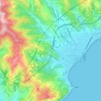
Name: Diano Calderina topographic map, elevation, terrain.
Location: Diano Calderina, Diano Marina, Imperia, Liguria, 18013, Italy (43.89209 8.04767 43.93209 8.08767)
Average elevation: 95 m
Minimum elevation: 0 m
Maximum elevation: 312 m
Thank you for supporting this site ❤️
Make a donation
Make a donation
Other topographic maps
Click on a map to view its topography, its elevation and its terrain.
Bordighera
It is estimated that the previous day had been cloudy with rain, a shower followed by a thunderstorm the night, with long lightning bolts to the east and west, and an elevation of no less than 2500 feet.
Average elevation: 102 m
Thank you for supporting this site ❤️
Make a donation
Make a donation