
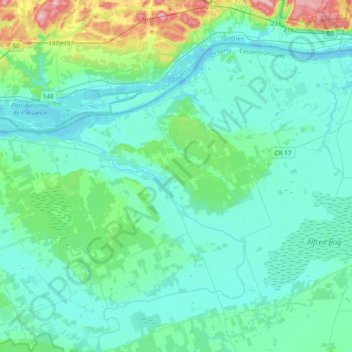
Alfred and Plantagenet topographic map
Interactive map
Click on the map to display elevation.
About this map
Name: Alfred and Plantagenet topographic map, elevation, terrain.
Average elevation: 71 m
Minimum elevation: 38 m
Maximum elevation: 260 m
Other topographic maps
Click on a map to view its topography, its elevation and its terrain.
Embrun
Canada > Ontario > Prescott and Russell Counties
Embrun, Russell, Prescott and Russell Counties, Eastern Ontario, Ontario, K0A 1W1, Canada
Average elevation: 69 m
Voyageur Provincial Park
Canada > Ontario > Prescott and Russell Counties > East Hawkesbury
Voyageur Provincial Park, East Hawkesbury, Prescott and Russell Counties, Eastern Ontario, Ontario, K0B 1B0, Canada
Average elevation: 45 m
Limoges
Canada > Ontario > Prescott and Russell Counties > The Nation > Limoges
Limoges, The Nation, Prescott and Russell Counties, Eastern Ontario, Ontario, K0A 2M0, Canada
Average elevation: 71 m
St-Eugène
Canada > Ontario > Prescott and Russell Counties > East Hawkesbury > St-Eugène
St-Eugène, East Hawkesbury, Prescott and Russell Counties, Eastern Ontario, Ontario, K0B 1P0, Canada
Average elevation: 59 m
Clarence-Rockland
Canada > Ontario > Prescott and Russell Counties > Clarence-Rockland
Clarence-Rockland, Prescott and Russell Counties, Eastern Ontario, Ontario, Canada
Average elevation: 71 m
The Nation
Canada > Ontario > Prescott and Russell Counties > The Nation
The Nation, Prescott and Russell Counties, Eastern Ontario, Ontario, Canada
Average elevation: 72 m
Hawkesbury
Canada > Ontario > Prescott and Russell Counties
Hawkesbury, Prescott and Russell Counties, Eastern Ontario, Ontario, Canada
Average elevation: 52 m