
Make a donation
Gore District topographic map
Click on the map to display elevation.
Make a donation
About this map
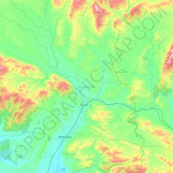
Name: Gore District topographic map, elevation, terrain.
Location: Gore District, Southland, New Zealand (-46.29885 168.70131 -45.79134 169.19829)
Average elevation: 203 m
Minimum elevation: 30 m
Maximum elevation: 827 m
Make a donation
Other topographic maps
Click on a map to view its topography, its elevation and its terrain.
Mount Tūtoko
New Zealand > Southland > Southland District > Fiordland Community
Average elevation: 1,892 m
Ohai
New Zealand > Southland > Southland District > Wallace Takitimu Community
Average elevation: 188 m
Make a donation
Forest Range
New Zealand > Southland > Southland District > Waihopai Toetoe Community
Average elevation: 373 m
Make a donation
Rakahouka
New Zealand > Southland > Southland District > Waihopai Toetoe Community
Average elevation: 38 m
Mount Elliot
New Zealand > Southland > Southland District > Fiordland Community
Average elevation: 1,110 m
Garston
New Zealand > Southland > Southland District > Northern Community > Garston
Average elevation: 373 m
Make a donation
Hollyford River
New Zealand > Southland > Southland District > Fiordland Community
Average elevation: 14 m
Lake Alabaster
New Zealand > Southland > Southland District > Fiordland Community
Average elevation: 605 m
Make a donation