
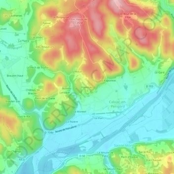
Fonnoyer topographic map
Interactive map
Click on the map to display elevation.
About this map
Name: Fonnoyer topographic map, elevation, terrain.
Average elevation: 140 m
Minimum elevation: 73 m
Maximum elevation: 249 m
Other topographic maps
Click on a map to view its topography, its elevation and its terrain.
Les Taillades
France > Nouvelle-Aquitaine > Dordogne > Calviac-en-Périgord
Les Taillades, Calviac-en-Périgord, Sarlat-la-Canéda, Dordogne, Nouvelle-Aquitaine, France métropolitaine, 24370, France
Average elevation: 138 m
La Paponnie
France > Nouvelle-Aquitaine > Dordogne > Calviac-en-Périgord
La Paponnie, Calviac-en-Périgord, Sarlat-la-Canéda, Dordogne, Nouvelle-Aquitaine, France métropolitaine, 24370, France
Average elevation: 142 m
Le Gard
France > Nouvelle-Aquitaine > Dordogne > Calviac-en-Périgord
Le Gard, Calviac-en-Périgord, Sarlat-la-Canéda, Dordogne, Nouvelle-Aquitaine, France métropolitaine, 24370, France
Average elevation: 139 m
Le Presbytère
France > Nouvelle-Aquitaine > Dordogne > Calviac-en-Périgord
Le Presbytère, Calviac-en-Périgord, Sarlat-la-Canéda, Dordogne, Nouvelle-Aquitaine, France métropolitaine, 24370, France
Average elevation: 137 m